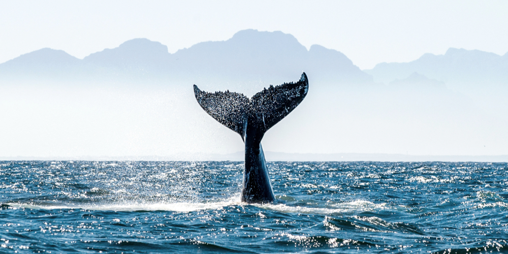
Oceans are inseparable parts of human life. It not only plays a central role in regulating the Earth’s climate and providing oxygen, but is also home to countless sea species. Hence preserving ocean ecosystems is vital to the prosperity of humanity. However, most people do not know how to protect the oceans and even do not know how oceans are protected. Without clear boundaries, it is difficult to clarify the marine protected areas and monitor the location of ships in the middle of the oceans.
Here is an organization committed to provide open data and monitoring solutions to enhance awareness and compliance of ocean protections.
The series tells the story of people who utilize technology to benefit our society and environment. NCSOFT believes that technology can contribute to a qualitative leap towards a better society. People can provide solutions for diverse problems using technology and set a new direction for humanity to go forward. The series start with ‘ProtectedSeas,’ who developed a free, public platform providing the map of Marine Protected Areas (MPAs) to raise awareness for ocean conservation.
How Technology Can Help Save Our Ocean
ProtectedSeas is a not-for-profit organization associated with Anthropocene Institute* and has an established public-private partnership with the NOAA MPA Center(National Oceanic and Atmospheric Administration- Marine Protection Center). ProtectedSeas focuses on improving processes of collecting and access to open data and information required for ocean conservation. Their key projects are developing the Marine Protected Areas (MPA)Map – making it accessible from a boat – and the Marine Monitor(M2) system.
* Anthropocene is a new word for today’s geological period, characterized by global warming and ecosystem encroachment due to human environmental destruction. The Anthropocene Institute is a researching organization to develop and nurture technologies, policies, and market mechanisms to solve global environmental challenges.
Each country designate MPAs, which are clearly defined geographical spaces, recognized, dedicated, and managed, through legal or other effective means, to achieve the long-term conservation of nature with associated ecosystem services and cultural values. In these areas, a variety of marine activities from fishing to recreational activities are allowed or restricted by level of protection. Many studies have shown that the designation of MPAs facilitates marine ecosystems restoration and improve biodiversity.
For the proper effectiveness of the MPA, it is important to raise the public awareness for regulations of each MPA. However, it can be difficult for people to be aware that they have entered a protected area or to know what kind of regulations apply or activities are allowed in given ocean space. “In the early days of the establishment, we looked for ways to protect our oceans more wisely. First, we had to figure out where the MPAs are located and how the oceans are protected in those areas. But finding this basic information was not easy, “said Director Vigil Zetterlind of ProtectedSeas. With the goal of bringing all the global MPAs and regulations into one data set, experts in relevant fields, including geographers, lawyers specializing in Marine Environmental law, and data engineers formed a team and finally a free, public MPA map has launched.
Global MPAs at a Glance
ProtectedSeas provides a digital map containing an open dataset of boundaries and regulations that apply to marine protected areas and marine managed areas around the world. ProtectedSeas collects data including detailed attribute information for MPAs in cooperation with the NOAA MPA Center (National Oceanic and Atmospheric Administration-Marine Protection Center), NGOs, and research centers around the world.
MPA regulations and the degree of restrictions vary from country to country. ProtectedSeas creates an easy-to-understand summary of the key restrictions, exceptions, and purpose of each site and assigns a 1-5 Level of Fishing Protection score to each area allowing basic comparisons. Unlike protected lands, the marine protected areas cannot set markers, and without clear boundaries, people can easily drift into areas where they don’t belong. Therefore, ProtectedSeas obtained boundary coordinates from government agencies or authoritative sources and developed the map using ESRI and open-source GIS tools.
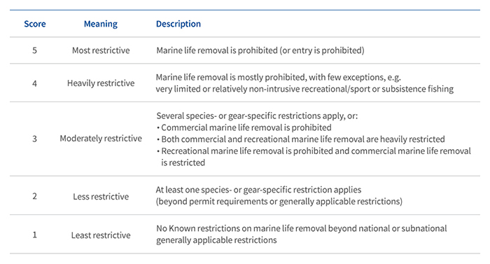
[Figure1] Level of Fishing Protection (LFP) score
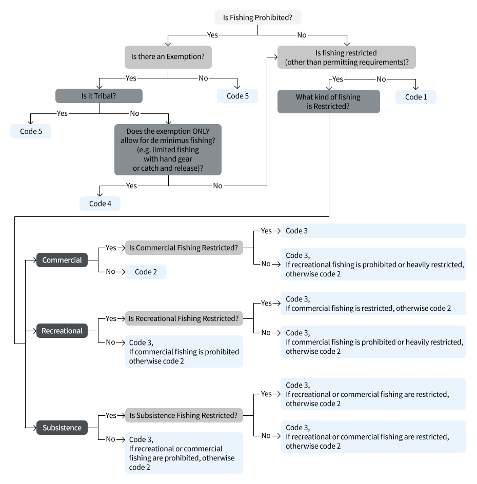
[Figure 2] LFP Decision Tree: Standardize the LFP scoring coded on a Likert 1-5 scale
The MPA map currently features 48 countries with more coming soon, and the datasets are continually updated. It also provides information about areas beyond national jurisdiction – the high seas – and areas that are not designated as MPAs but provide conservation benefits through fishing restrictions. The MPA map is currently available in 13 languages, including English and Korean, and works on most desktop and mobile devices.
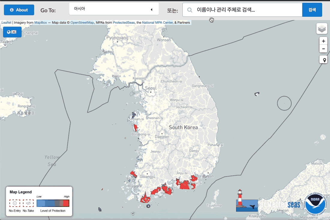
[Figure3] How to search and use the MPA map
M2, a 24/7 Maritime Surveillance system
Preserving the marine protected areas is challenging since illegal fishing and restricted activities can occur at night and early in the morning. Therefore, ProtectedSeas developed a 24/7 marine monitor, M2 – a marine radar system that tracks boat activity and illegal fishing in nearshore waters (out to 5 miles). Because M2 is built with commercial off-the-shelf marine radar hardware available world-wide, it is easy to deploy and maintain globally at a lower cost. User access is cloud-based and easy to use on any computer or smartphone.
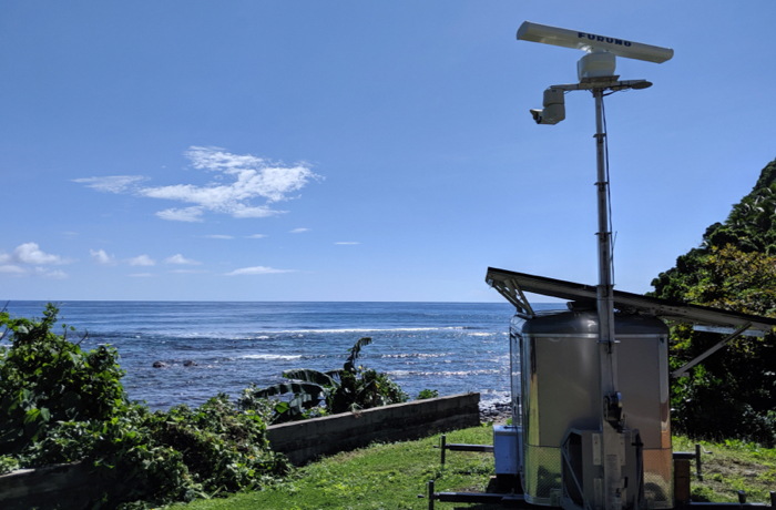
[Figure4] M2 installed on the seashore
Moreover, when MPA maps are paired with Marine Monitor (M2) systems, they assist with monitoring and documenting illegal fishing in 16 nearshore MPAs around the world. NGOs and academic and government partners use M2 to get automatic alerts of vessel loitering activity inside of MPAs and pass on to marine enforcement. The potential synergy between the MPA maps and M2 systems is playing significant role in strategic MPA management.

[Figure5] M2 records suspicious activity in MPAs.
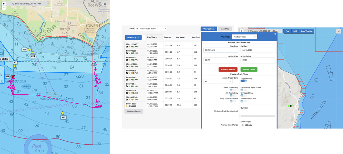
[Figure6-Left] The M2 software system enables real-time views of radar data online and stores historical track data.
[Figure7-Right] The M2 system continually collects data with or without an internet connection as long as the system has power.
Applying Technology to Practical Ocean Conservation
ProtectedSeas’ projects make a positive impact on a variety of ocean conservation activities. MPA data raise awareness of fisherman, marine workers, and the general public about the regulations. Moreover, MPA data accumulated from various projects is recognized for its effectiveness and validity by global partners, governments, and other organizations.
The International Hydrographic Organization (IHO) used MPA Map data to test its newly developed data standard to display MPAs on electronic charts used by large ships. Also, any country can use MPA data to calculate protection levels more precisely and measure their progress towards the United Nations Sustainable Development Goal 14 ‘Conserve and sustainably use the oceans, seas and marine resources for sustainable development.’
At the same time, the M2 product is used by dozens of local governments, NGOs, and academic partners in seven countries. For example, WILDCOAST, an international non-profit environmental organization based in San Diego, California, utilizes M2 as a critical tool for education and outreach to raise public awareness about the importance of MPAs and reports illegal activities in state protected areas to the authorities. Data collected from M2 systems have been used to advocate for increased resources for law enforcement and a need for better regulations to ensure the effective conservation of California’s MPAs.
ProtectedSeas plans to complete global MPA coverage by 2022. Deployment of M2 has been delayed due to COVID 19 this year, but many new M2 sites will launch in the next 18 months. The vast MPA data accumulated by ProtectedSeas have been widely used to promote ocean protection. Their first academic paper, looking at levels of protection of U.S. waters, was recently published in the Marine Policy journal and they are working on their second paper exploring how to calculate global protections. ProtecetedSeas will continue to find better solutions using technology to enhance public awareness for ocean conservation.
The story continues in the following interview with Director Virgil Zetterlind of ProdecedSeas. Link
* The NC provides ProtecetedSeas with data on marine protected areas in Korea since 2020. On the ProtecetedSeas’ MPA map, you can find information about MPAs in Korea.
 Facebook
  Twitter
  Reddit
  LinkedIn
  Email
Email  Copy URL